Contact the abode
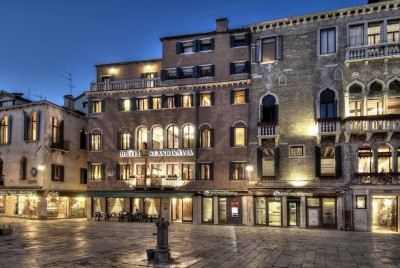
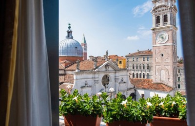
Hotel Scandinavia has all the discreet charm and decadent atmosphere of one of the oldest Palazzos in Venice. Located in the heart of the city, a stone's throw from St. Mark's Square and the Rialto Bridge, it has a splendid view over Campo Santa Maria Formosa and its guests are guaranteed to enjoy an enchanting stay in a truly authentic Venetian setting. The current owners of this former residence which has been converted into a hotel, the Tinacci family, acquired the historical property from the previous owner and have inherited that same spirit of hospitality. Long-standing trade connections with the Scandinavian countries was a primary reason for the building's historical role as a commercial hub, as was exemplified by the Hanseatic League.
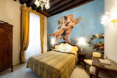
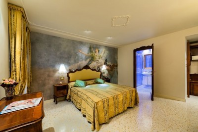
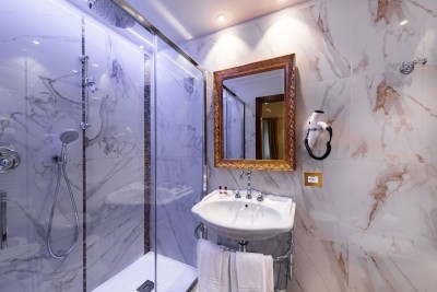
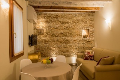
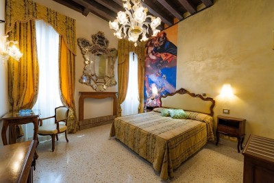
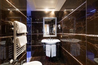
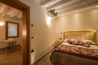
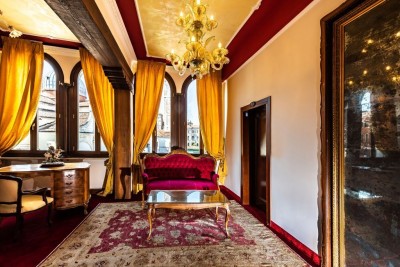
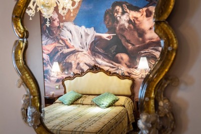
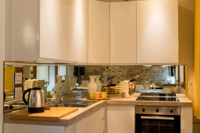
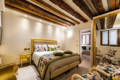
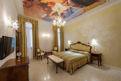
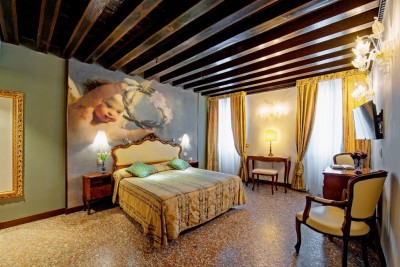
Staying at Hotel Scandinavia is a unique and exhilarating experience that will allow visitors to immerse themselves in a bygone era, reliving the era of the ancient splendour of 18th-century Venice. Every room at the Hotel has been designed to recreate this magical atmosphere. Hotel Scandinavia has 33 spacious and bright rooms, which have all been tastefully furnished with period furniture and sumptuous Murano glass chandeliers, and which are equipped with every modern comfort, including TV, minibar, direct dial telephone and air conditioning. There are also 2 apartments adjacent to the hotel.
The building stands on foundations dating back to Roman and subsequently Byzantine times, which consisted of stakes embedded into the silt of the lagoon, surmounted at different periods of time by walls representing the characteristic form of a Venetian Palazzo. The central structure of the building facing Campo Santa Maria Formosa is the original body of the Palazzo, to which other adjoining portions have been added in more recent years. It is here that, during extensive renovation work, ancient documents were discovered, stored under the beams of the residence, which referred to the purchase of silver coins at the Venetian mint, specifically for the purpose of trade. While maintaining the classic 18th-century furnishings, the Tinacci family has sought to preserve the original appearance of the Palazzo, later enriching it with a collection of modern art paintings placed on the upper floors of the building.
THE HISTORY OF HOTEL SCANDINAVIA
The Sestriere (or district) of Castello is situated between the lagoon on the north and east sides and the areas of San Marco and the Cannaregio district to the south. It represents the most archaeologically interesting sestiere and is the richest in terms of its historical and geo-archaeological information.
The foundation of the settlement of San Pietro di Castello spans several centuries and encompasses three distinct colonisation areas: the insula saneti Petri citra pontem (the island of Saint Peter this side of the bridge), the confinium castellanum ultra pontem (the boundary of Castello beyond the bridge), and the contrada saneti Petri de Castello (the district of Saint Peter of Castello).
The first corresponds to the island of Olivolo, where there was a Byzantine exarchal command post (castrum Helibolis) on the inland-coastal navigable route of the Imperial age that connected Ravenna with Aquileia. Recent excavations near the church of Saint Peter revealed a settlement from the 7th-century and remains of wooden buildings. Evidence of an episcopal district with a cathedral and a palatium, probably built on the foundations of the ancient castellum, was found on the island, as well as traces of the contiguous Baptistery of San Giovanni, identifiable with the Church of San Sergio and San Bacco, the residences of the archdeacon and canons, other houses for the landlords, notaries and servants (such as boatmen and gardeners), and an extensive vineyard.
A valuable land register drawn up by Bishop Ramperto Polo (1303-1309) in the early 14th century as a result of numerous property acquisitions made during the previous century, documented the plots and buildings existing in the south-western part of the island. All the constructions appear to have been fairly simplistic and were mostly on a flat plane and made of wood. The document confirmed that most of the area was originally owned by the bishops. Information gleaned from the deeds of concession of ecclesiastical settlements like San Daniele (1138), Santa Maria in Jerusalem (delle Vergini, 1239), Sant’Elena (1175 and 1233) and Sant’Andrea de Littore (della Certosa, 1199), as well as a judgment passed by the judges of Piovego, helps shape the picture of a vast archaic property in the lands and waters of the Castello episcopate around the Olivolo settlement.
The second area encompasses the island of Campo Ruga, which lies between the Canale di Castello, the Sanctus Danielis ridellus (stream) or rivus (rivulet), which is the ‘rio di San Daniele’, the Sanctus Petri or de Castello rivus (the ‘rio de Sant’Anna’) and the rivus di Santa Maria delle Vergini. Until the beginning of the 14th century, the settlement was clearly semi-agricultural, comprising a complex of pecie de terra (plots of land), which were either vacua (vacant) or partially used for mostly wooden residential constructions. The aforementioned cadastal records indicate 15 wooden domus (houses) and 5 domus de muro (stone houses). By this time, however, the confinium castellanum ultra pontem boundary of Castello beyond the bridge no longer belonged entirely to the curia (ecclesiastical court): a decent-sized plot in the north-west corner was owned by the Monastery of San Daniele, which also owned a number of small houses as part of the episcopal partitioning, as was also the case of the Monastery of Santa Maria delle Vergini. The south-west and north-east corners also appeared to be owned by private individuals or had been acquired by the municipality.
The land regime of the episcopal estates was the very ancient one of livellum (leaseholding), which required renewal every 29 years and granted the lessee the right to sell the land, subject to the right of pre-emption of the curia. In the Polo cadastral register, this was closely tied to the notification that the lessee had to fulfil in such circumstances. The livellum obligation was generally very light, usually an annual requirement of one or two bonas gallinas (good hens) or one or two pairs of bonorum capponorum (quality capons). However, there were many instances where the obligation was to provide duas fialas boni vini (two flasks of good wine) or five pounds (or a metre) of boni et puri olei (good, pure oil), without apparent justification for the considerable difference in the size of the always accurately measured pecie de terra. The measurement of the land parcels offered by the land registry makes it possible to establish with sufficient precision, together with the consideration of the current ground levels, which were quite high along the Riello and very low towards the Canale (90,80 cm or less), that the island was much narrower in the 14th century than it is today and that, in the 12th and 13th centuries, conditions of discomfort or difficulties in terms of residence and cultivation could well have existed, due to the higher sea level.
The documented land division cannot therefore be established much earlier than the 13th century. It served two specific road functions. One was the road connecting the confinium (boundary) by means of a pons longus (long bridge) over the Canale de Castello with the Campus Sancti Petri (1352), which may have replaced another bridge further south, as documented in 1298. The other was another bridge over the Rio de Sancta Anna towards the wider road, which was dependent on the former and allowed access to the monasteries of San Daniele and Santa Maria delle Vergini via other bridges. The central axis was a via publica (public road) which led to a campus vinee (meaning a place where vines were cultivated, today known as Campo Ruga), originally owned by the episcopal curia. By the beginning of the 14th century, at least in part, it had become a public place allowing introitus et exitus (entry and exit) for frontisti (those who owned property on the road) and passers-by.
The third settlement area, the contrada (its very name indicates that it was established after the boundary confinium), was on both sides of the rivus sancti Petri and ran all the way to San Biagio along a course of approximately five hundred and seventy metres, characterised by its comb-like urban layout. The individual frontisti had to guarantee the maintenance of their own stretch of via communis or public road (today’s ‘Fondamenta’) along the rivus, which represented the prestigious residential area opening towards the city of the entire Castello complex. The sense of community was more dynamic and lively compared to the two other areas, in no small part due to the expansion of the nearby Arsenale shipyard. The contrada district called for an innovative design, which involved the marking out of two terminationes (endpoints) at different distances of 30, 40 and 50 feet apart, while the excavation of the canal continued westward until it reached the marshland known in the 1430s as puncta vehelme at the beginning of the significant curve in the ‘Canale Maius’ (today’s Grand Canal).
The alleyways perpendicular to the rivus were developed in later phases of urbanisation, during which time the gradual expansion of the area behind these streets was driven by the establishment of the first rental lots, both to the north (extending to the Tane Canal, a project initiated by the municipality in the 1420s) and to the south (stretching to the Canal or newly reclaimed lands from the swamp). This expansion necessitated the creation of numerous access routes to facilitate movement around the growing settlement.
In the late 14th century, moreover, an entirely new phase of territorial transformation began, driven by massive land reclamation initiatives in the southern marshland as authorised by the government and put into effect by enterprising citizens, such as those carried out in 1318 and 1334 by Marco Catapan and Magister Gualterius, who was a cerusico (a master surgeon). The significant expansion of territory in this area was marked by the establishment of the Monastery of Sant’Antonio di Vienna (1346), followed by the addition of other monasteries like San Nicolò di Bari and San Giuseppe in the sixteenth century. This expansion primarily occurred in the eastern part of the contrada, following the course of the canal. In contrast, the western part, located at a distance from both the Castello and San Marco centres, experienced smaller-scale development. This western area was mainly used for vegetable gardens and various ship-building construction and artisanal activities, with an emphasis on preserving private open spaces. The existing documentation of public concessions and private acts related to the above-mentioned enterprises, however, raises many doubts and makes it difficult to be certain of some locations, with the exception of the definition of the appurtenances of the Monastery of Sant’Antonio and the identification of the ten-foot-wide via publica required by the municipality along the Canal up to the northern connecting bridge with the calle of the Monastery of San Domenico.
A comparison between the land grants given to Valterio and Catapan and the detailed depiction of the de' Barbari area reveals significant disparities. Valterio's allocation of water resources was considerably larger than the undeveloped lands depicted in the 1500 view. Moreover, the planned canal and road connecting his area to Catapan’s had not yet been built. There was also a lack of compatibility between the various land concessions granted to Valterio and those to Catapan. These grants persisted for decades and resulted in complex and confusing transactions, including sales, repurchases and exchanges among private individuals. Furthermore, the precise location of the Hospital of San Giovanni intended for elderly mariners, which was undoubtedly constructed by Valterio, remains unknown, as it disappeared from historical records relatively quickly. This hospital was intended to constitute one side of the extensive area assigned to the botanical garden that the cerusico had envisioned creating. It is therefore plausible to presume that Valterio's allocation among his numerous relatives in his will of 1343, which reflects a systematically organised geometric distribution of the land, was not implemented in practice. This assumption is further supported by the issuance of a new, reduced concession in 1358 to his nephew, Luciano Martella, a cirologus (physician), which replaced the deceased's grant.
While many of these initiatives were left unfinished, a massive expansion project was initiated at the arsenal during this same period. This expansion project focused on the large reservoir known as the lacus Sancti Danielis, which had been transferred from the Bishop to the Monastery and was used as an aqueduct for many years before being acquired by the Commune in 1325. The expansion efforts also involved the construction of extensive rope-making factories to the north of the Rio de la Tana. This development facilitated the relocation of hemp storage and processing activities, which had previously been located in San Geremia, to the new arsenal area enclosed by the city walls.
In this overall context of considerable but modest development, ecclesiastical and charitable foundations, which were more numerous in the parish of San Pietro than in any other urban region, also played a role. While the insula Sanctus Petri remained physically distant from the expanding contrada, and San Daniele, which was granted to the Cistercian Abbot of Fruttuaria in 1138 and enriched with a large molendina (lake for mills) in 1220, as well as Santa Maria in Jerusalem, which succeeded an older church dedicated to the Holy Saints John and Paul, were also situated on the periphery, new institutions found their place along the inhabited axis of the rivus Sanctus Petri. In 1242, a hermit friar from Fano purchased some land to establish a monastery dedicated to Santa Maria di Nazareth, which operated for fifty years until it was relocated under the new name of Santo Stefano to a neighbouring area between the parishes of San Vidal and Sant'Angelo. In its place, in 1297, a monastery for women dedicated to Sant’Anna was established and expanded through the acquisition of adjacent properties.
In his will in 1291, Bishop Bartolomeo I Querini ordered the foundation of a hospital named after his namesake saint, which was already in existence along with its church by the year 1303. In 1312, Doge Marino Zorzi made similar provisions for the establishment of a Dominican monastery, along with a hospital. The former, bearing the title of San Domenico, was already in operation with a Romanesque-Gothic transitional church by 1317, and the latter, thanks to an acquisition in 1343, was erected next to the portico of the church by 1347 and was referred to as the hospitale domicellarum. The territory of the monastery was gradually expanded southward through purchases and grants, eventually reaching a stream that separated it from the afore-mentioned Monastery of Sant'Antonio, along the western section of the present-day Rio de Sant'Isepo.
All these monastic churches have since disappeared. Worth mentioning, however, is the very ancient and important hospital of the Saints Peter and Paul, which, along with the nearby hospitaleto da cha Avançio, was located in the centre of the district, on the corner with the Rio de la Tana. It was placed under the administrative protection of the Doge in 1368, at the request of its Prior Marco de Bonaccursio.
From a sociological perspective, records reveal a population that is modest in size and was engaged in various trade occupations, ranging from strazaroli (tailors) to venderigole (street vendors), from mulinarii (millers) to pancogoli (bakers), and from cortelarii (cutters) to marangoni (carpenters). However, there were also many illustrious families (Bonzi, Venier, Nani, Zorzi, Zusto, Soranzo, Acotanto, Pisani, Zen, Alberegno, Sanudo, Diedo, Trevisan, Signolo, Belegno). One of the most prominent was the Correr family, who counted among their number a high-ranking ecclesiastical primicerio of San Marco who later became Patriarch of Constantinople.
The list of contributing taxpayers in the census of 1379 is not very informative in this regard, as it only mentions the assets of a certain Betino, although it highlights the substantial property values of the Monasteries of Vergini and San Nicolò di Lido.
THE PARISH OF SANTA MARIA FORMOSA
Legend has it that the Blessed Virgin appeared to Bishop Saint Magno and told him to erect a church over the area where he had seen a white cloud overhead. Her wish was his command, and the new church, built with the co-operation of the Tribuno family, was dedicated to the Purification of the Blessed Virgin and became known as ‘Santa Maria Formosa’ in memory of the indeterminate form in which the Mother of God had appeared to the Bishop. This parish church was rebuilt not even two centuries later in 864 by the sons of Marino Patrizio and was then built again after a fire destroyed it in 1105. Its foundations were raised in 1492 according to a design by Moro Lombardo. In 1541, the façade facing the Ponte was constructed, followed in 1604 by one facing the Campo, which was commissioned by the Cappello family in the style of Sansovino. This architectural style was also applied to the interior renovation work carried out in 1689 by wealthy merchant Torrino Tonini. The church of Santa Maria Formosa underwent further interior restoration in 1842.
With regards to the parish, its boundaries were modified in 1810 when it lost some of the neighbourhoods that were associated with the two parishes of San Zaccaria and Santissimi Giovanni e Paolo, while acquiring others that had belonged to Santa Marina and San Giuliano, along with the entire surrounding district of San Leone.
The famous 16th-century Venetian poet and courtesan Veronica Franco ‘retired’ to the parish of Santa Maria Formosa and is cited in a very rare pamphlet, printed in the 16th century and entitled: ‘This is the Catalogue of all the most Important and Honourable Courtesans of Venice’, of which Cicogna possessed a hand-copied manuscript, which is now on display in the Civic Museum. It confirms her residence there as follows: “Vero. Franca a Santa Mar. Formo. Pieza so mare. Scudi 2” (Veronica Franco at Santa Maria Formosa. Canal-facing room. 2 ducats).
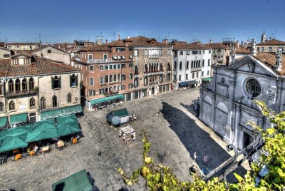
The ‘Campo di Santa Maria Formosa’ is distinguished by the presence of various Palazzos. On the right, near the Ponte di Ruga Giuffa, is Palazzo Malipiero, later also known as Palazzo Trevisan, which was designed in the 16th century by Sante Lombardo. In the centre of the Campo, at the entrance to the ‘Calle degli Orbi’, stands the ancient Palazzo Vitturi. After passing the ‘Calle Lunga’, there are also ancient Palazzos owned by the Donato family, one of which features a marble head with the family’s crest above the door. This was the residence of Ermolao Donato, one of the leaders of the Council of Ten, who, "...While returning home on 5 November 1450 at 4 o'clock in the morning, received various wounds inflicted by an unknown assailant at his doorway, which, after two days, led him to the grave”. Accused of complicity in his murder, Jacopo, the son of Doge Francesco Foscari, was captured, tortured and tried by the Council of Ten before being exiled to Crete for life, after refusing to confess to any crime. On the northern side of the Campo, meanwhile, is Palazzo Ruzzini (also known as Palazzo Priuli Ruzzini Loredan), which was designed by Bartolomeo Monopola.
DOCUMENTS AND ARCHIVAL SOURCES
Archival research has been conducted, consulting the available historical records. What we have found for the medieval period speaks of an area occupied by properties for which we lack archival documentation, and a calle (street), which was only constructed from the 1300s onwards, as highlighted by Dorigo in his work ‘Venezia Romanica’ (2003). Examining perspective plans by de' Barbari (1500) and works from the 1600s (Merian & Merlo) have made it possible to identify the Palazzo facing Campo Santa Maria Formosa and its annexes on Calla Longa. They show a two-storey building with a series of lower buildings behind it, which has been raised due to modern restoration work. Excavations carried out within the residence a few years ago revealed original masonry from the Byzantine era.
The residents inhabiting the property at the time were a family of merchants known by the name of Trevisan, who had established steady trade relations with Scandinavian countries from the first half of the 15th century onwards. As early as the second half of the 13th century, organised groups of merchants from the lagoon city represented trading groups oriented towards the Baltic Sea and the North Sea and needed to maintain their acquired positions. Commerce involved the maritime transport of various goods, from spices that were obtained in Venice from the East to the precious fabrics, herrings and tanned hides skilfully produced in the Scandinavian regions. Trade continued to strengthen until around 1450, thanks to the formation of the Hanseatic League, which protected trade in Northern Europe.
The Palazzo is located in an extremely active and pivotal area for commercial activities: from the fifteenth century onwards, it remained a landmark in Campo Santa Maria Formosa, undergoing partial modifications both inside and outside. In the 19th century, the property facing Campo Santa Maria Formosa was divided into a considerable number of internal subdivisions. A more contemporary layout is visible inside the building, while the structures on Calle Longa appear almost unchanged. Archaeological excavations have revealed the ground on which the residential structures visible in de' Barbari's perspective plan (1500) were built.
Documentary sources describe the Palazzo and specify that it was owned by the Trevisan family. The complex appeared to be subdivided in the 14th century, but the original building dates back to the latter part of the century, as evidenced by a foundation wall with knife-edged bricks bound by lime mortar, located at a height of +20 cm above sea level and running in a northwest-southeast direction. Through archaeological analysis and the comparison with archival records, these can be attributed to the residential structures mentioned by Dorigo in his ‘Venezia Romanica’.
A wall complex, which can be traced back to the 15th century, is currently preserved on the ground floor; the masonry features a structure resembling an arch, created to seal and strengthen a pre-existing opening. This operation took place in the 16th century during the second expansion of the building, as documented based on de' Barbari's plans. Thanks to this brick arrangement, the wall’s structures were strengthened, and the door was permanently closed.
The wall appears as a complex system of bricks and mortar, which has been renovated in contemporary times. By analysing the shape and size of the bricks, it can be deduced that some of them date back to the 15th century, while others are from a more recent period, and still others are even older, possibly originating from a pre-existing structure. This opening, therefore, marks the perimeter boundaries of the 15th-century building, which was built upon an older complex, confirming that the Palazzo has its origins in the late 14th century and that its original size was smaller than what is currently visible. The Palazzo as it appears today underwent its first expansion in the 15th century when the second floor was added, and its size was consequently increased, reaching its zenith in the 16th century with a second round of structural modifications and a series of subdivisions. A third significant expansion was carried out in the 19th century with the addition of another floor, together with some structural modifications still present today.
CONCLUSION
Jacopo de' Barbari's 16th-century perspective plan provides us with a visual representation of the volumetric layout of the complex now occupied by Hotel Scandinavia, which housed a merchant family at that time. The two-storey building described has a series of lower buildings at the rear. The perpendicular orthogonal masonry with its north-south orientation, can be attributed to this phase of the structure, referable to an internal subdivision of the building. The original Palazzo, dating back to the late 14th century, with all of the subsequent modifications and subdivisions that occurred in modern and contemporary eras, is set on natural clayey soil, the upper interface of which is located at +32 cm above mean sea level. The building features structures that are clearly from the 15th century with evidence of late 14th-century masonry, as revealed by archaeological excavations conducted in 2017 on the ground floor. Comparisons between archaeological documentation and archival sources confirm the antiquity of this Palazzo, which can be regarded as a fine example of a historical residence in the heart of the city of Venice.